Two quakes minutes apart hit Venezuela's coast, shaking Caracas and putting millions in the impact zone
A magnitude-7.1 quake near Morón, followed by a near-simultaneous second shock, collapsed buildings across Venezuela's capital on 25 June 2026 and put millions inside the USGS impact zone.
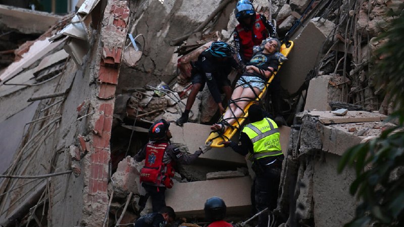
Two strong earthquakes struck northern Venezuela within minutes of each other on the morning of 25 June 2026 (UTC), collapsing buildings in Caracas and putting a population Monexus estimates in the millions inside the United States Geological Survey's impact zone. The first shock registered magnitude 7.1 and originated roughly 13 kilometres below the surface near the coastal city of Morón, on the country's central Caribbean shoreline, according to the USGS. A second, near-simultaneous event followed, producing the cascading building failures visible across the capital in the first hours of footage. By 00:29 UTC, DW was reporting that the USGS had formally classified the event as one in which "high casualties and extensive damage are probable." As of this article's publication, the full casualty toll, the precise magnitude of the second shock, and the structural status of damaged buildings in Caracas remain in flux.
This is not a one-off jolt. Northern Venezuela sits along the boundary between the Caribbean and South American tectonic plates, and the Morón–Caracas corridor has produced damaging events before. What makes Wednesday's sequence worth watching is the back-to-back character of the shocks and the density of the population they hit — Caracas, a metropolitan area of several million, sits close enough to the epicentral region to feel the strongest shaking, while the wider Caribbean coast absorbed the brunt of the first rupture. The USGS's PAGER system is built precisely for this kind of moment: rapid, country-level estimates of population exposure and likely damage, designed to outrun the slower humanitarian reporting that follows.
The first minutes: what the wires show
The USGS placed the principal shock at magnitude 7.1, with a hypocentre near Morón at a depth of 13.2 kilometres, France 24 reported at 00:13 UTC. Within minutes, OSINT aggregators on Telegram were describing a "double-event" pattern — an initial 7.2 followed by a 7.5 — and quoting USGS projections that the shaking was felt by millions across a wide range of Venezuelan territory, with projected injuries and fatalities described as serious. Telesur's English desk, citing the USGS directly, put the headline magnitude at 7.1 and the depth at 13.2 kilometres, while attaching video from Caracas that showed damaged structures. The numerical disagreement between the wires and the OSINT feeds — magnitude 7.1 versus 7.2/7.5 — is itself part of the story; USGS magnitudes are routinely revised in the hours after a major event as additional seismic stations contribute readings. Monexus treats the agency's first public figure (7.1, 13.2 km depth) as the operative number for now, with the caveat that it is likely to move.
Counter-narrative: what the early images actually show
The OSINT-driven framing — a "massive 7.5" event, projected mass casualties — outran the verifiable record in the first hour. Video out of Caracas that circulated on Telegram and via Telesur showed partial collapses of mid-rise buildings, fallen façades, and residents in the streets, but the footage did not by itself establish either the magnitude of the second shock or a national casualty figure. The USGS's PAGER product, which the DW report cited, is a probabilistic estimate rather than a count; it is built to give first-responder agencies a sense of the scale of impact before field reports arrive. Monexus's reading: the dominant frame in the first hour — a single catastrophic event of magnitude 7.5 — is almost certainly wrong on the precise number, even if the underlying concern about extensive damage in Caracas turns out to be correct. That distinction matters because early magnitude figures feed directly into insurance loss estimates, sovereign-bond pricing, and humanitarian-funding decisions, all of which are already in motion in Caracas.
Structural frame: a country already strained
A seismic event of this size lands on a Venezuela that is operating with reduced institutional slack. The country has spent the better part of a decade under sanctions, hyperinflation, and outward migration on a scale that has reshaped the Caribbean. Earthquakes do not respect sovereign balance sheets, but damage assessments do: the speed of inspection, the deployment of search-and-rescue teams, the availability of heavy equipment, the state of building-code enforcement — all of these are downstream of fiscal capacity. The Caracas skyline contains a mix of mid-century concrete construction and more recent informal expansion, and the country's seismic building standards have long been a subject of engineering critique independent of the political economy. Without a humanitarian appeal or an offer of external assistance on the wire at the time of writing, the structural question is whether Caracas can run a credible damage assessment on its own in the next 72 hours. That is the variable worth watching more than the headline magnitude.
Forward view: what to watch
Three things will clarify in the next 24 to 72 hours. First, the USGS will revise the magnitude and depth of both events; the published figure will almost certainly move from the initial 7.1 toward a slightly higher or lower value once additional stations are processed. Second, Venezuelan civil-protection authorities and the regional seismic networks will publish a first consolidated casualty count, which at the time of writing has not been released to the wire. Third, the international humanitarian system will signal whether it is treating this as a domestic emergency or as one warranting external mobilisation. The Caribbean coast between Morón and Puerto Cabello, the Caracas metropolitan area, and the central valleys are the geography most at risk of aftershock damage and of secondary impacts on already-weakened infrastructure. The structural reading: the immediate story is a seismic double-event on an under-instrumented coastline. The longer story is what the response architecture can absorb.
Monexus framed this as a developing natural-disaster story sourced primarily to USGS-adjacent wire reporting and OSINT aggregators. Where the OSINT feeds outran the verifiable record in the first hour, this publication has flagged the discrepancy rather than smoothing it over.
Wire provenance
This editorial synthesis draws on the following public wire/social posts:
- https://t.me/s/osintlive
- https://t.me/s/osintlive