Satellite imagery confirms damage at Ramat David as Iran-Israel exchange enters second week
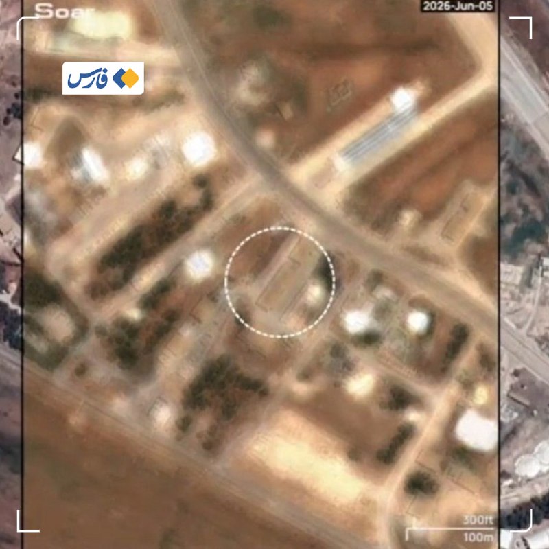
Commercial satellite imagery reviewed by Israeli and Western outlets has confirmed structural damage at Ramat David air base in northern Israel from Iran's missile barrage on the night of 7 June 2026, ending roughly 36 hours of conflicting claims about the operation's effect. The Times of Israel, reporting on the imagery on 10 June, identified damage to a hangar and a warehouse at the base, an Israeli Air Force installation east of Haifa that has long hosted F-15 and F-16 strike aircraft. The acknowledgment by an Israeli outlet tracked the more emphatic claims already circulating in Iranian state media and on Fars-affiliated Telegram channels, which on the same morning published imagery they described as showing destruction of the same facilities.
What matters beyond the kinetic fact is the way the exchange of claims is being arbitrated. Satellite commercial imagery has become, across two years of Middle East crises, the most reliable adjudicator when official Israeli and Iranian statements diverge — and it has again done that work, though within constraints the public cannot fully verify.
A corroboration, not a reversal
Israeli outlets and officials have historically been reluctant to enumerate damage from incoming fire. The Times of Israel report on 10 June, citing satellite images, framed the damage to Ramat David as a confirmed outcome of the Iranian strike package. Iranian state broadcaster Al-Alam carried the same findings on its Telegram channel, quoting the Israeli outlet directly. Fars News, the outlet closely tied to the Islamic Revolutionary Guard Corps, published what it described as satellite imagery of "the destruction of the hangar and warehouse of the Ramat David Air Base" in its own 10 June morning bulletin.
The convergence of an Israeli outlet, a Western-wire-friendly framing, and Iranian state media around the same basic finding is unusual. It is not a reversal of Israeli strategic communications, which continues to frame the broader air-defence outcome as successful. It is, however, an acknowledgment that the Ramat David installation absorbed a hit serious enough to show up on commercial resolution imagery.
What the imagery does and does not show
Satellite imagery of the kind referenced in the 10 June coverage typically allows for the identification of roof and wall damage to large structures, scorch marks on tarmac, and cratering. It does not, in commercial resolution, permit reliable assessment of runway usability, internal damage to aircraft hangars, or the operational status of squadrons housed within. The Times of Israel report, as carried by Al-Alam, is precise about what is observable: damage to a hangar and a warehouse. It is silent on the question that matters most for force posture — whether aircraft were lost or rendered non-mission-capable.
The same epistemic limit applies to the Iranian side. Fars and Al-Alam both published imagery and claimed destruction of the same facilities. Their framing — "destruction" — is more absolute than the Israeli reporting, which describes "damage." The gap between the two characterisations is the gap between what commercial satellite imagery can support and what each side's narrative requires.
The structural frame
Three patterns are worth holding in view. First, the tempo: an exchange that began on the night of 7 June has produced, within roughly 60 hours, a publicly accessible record of damage at a major Israeli air base that the Iranian side had specifically named before the strike. Second, the information environment: the confirmation has come through commercial satellite imagery and Israeli outlet reporting, with Iranian state media amplifying both the imagery and the Israeli acknowledgment. Third, the asymmetry of disclosure: Israeli reporting specifies damage; Iranian reporting claims destruction. Neither side has, as of the morning of 10 June, published a full assessment of operational impact.
The broader pattern is one in which commercial satellite providers — Planet, Maxar, BlackSky, ICEYE — have become a de facto fourth party to Middle East military exchanges, with both governments and publics relying on their products to evaluate claims that official channels have political reasons to soften or amplify. The 7 June exchange is now the third major Israel-Iran confrontation in which such imagery has been central to the post-strike public record.
Stakes and what remains contested
For Israel, the immediate stake is operational continuity at Ramat David and the political question of how publicly to enumerate the cost of a strike that crossed the country's airspace and reached a strategic installation. For Iran, the stake is whether the 7 June operation can be presented, at home and to an audience in the Axis of Resistance, as a confirmed successful strike on Israeli military infrastructure rather than a symbolic gesture. The satellite imagery tilts that contest in Iran's direction on the narrow question of physical damage, while leaving open the wider question of strategic effect.
Several things remain genuinely uncertain on the morning of 10 June. The full inventory of damage to Israeli aircraft, runway sections, and munitions storage at Ramat David is not publicly verifiable from commercial imagery. The number of Iranian missiles that reached the base — as distinct from those intercepted by Israeli and allied air defence — has not been disclosed in the reporting reviewed. The trajectory of the exchange over the coming days, and whether further rounds follow, is not predictable from the imagery alone. And the political handling of the damage assessment inside Israel — including any eventual cabinet-level discussion of response — has not, as of the time of this report, been confirmed in the source material.
The honest reading is narrow but real: the 7 June Iranian strike package produced visible, satellite-confirmed damage at a major Israeli air base, and the Israeli press has now, through the language of satellite assessment, said so. That is a fact with operational, political, and deterrent implications. The larger question — what it changes — is one that this publication, like the imagery on which it is reporting, can only partially resolve.
Desk note: Monexus treats the satellite record as the operative factual ground in this story, with Israeli and Iranian official framing both presented as advocacy rather than as primary evidence. The piece deliberately distinguishes between damage (Israeli outlet framing, supported by imagery) and destruction (Iranian outlet framing, also citing imagery), and does not extrapolate beyond what commercial resolution can show.
Wire provenance
This editorial synthesis draws on the following public wire/social posts:
- https://t.me/alalamfa
- https://t.me/farsna
- https://t.me/FarsNewsInt