Israel publishes expanded southern Lebanon occupation map, as Hezbollah releases bulldozer strike footage
On 18 June 2026 the Israeli military published a map detailing an expanded occupation of southern Lebanon, hours after Hezbollah released footage of a 13 June drone strike on an army bulldozer near Majdal Zoun.
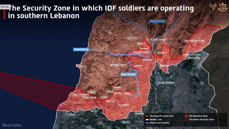
On the morning of 18 June 2026, the Israeli military released a map showing an expanded zone of southern Lebanon under its ground control — the most detailed public demarcation of the buffer it has carved into Lebanese territory since hostilities with Hezbollah intensified earlier this year. The map, circulated by regional outlets including The Cradle, sets out a perimeter that extends well beyond the line of villages along the Litani river that has historically defined the operational contact zone between Israel and Hezbollah. Hours earlier, the Iranian-aligned group had published its own statement of presence: combat footage, dated 13 June, of a drone strike that disabled an Israeli army bulldozer on the outskirts of Majdal Zoun, a town in south Lebanon that sits squarely inside the newly-published occupation arc.
The two releases, dropped within hours of each other, are not symmetrical. One is a cartographic assertion of permanent control; the other is a denial of that assertion, recorded by a single munition. Read together, they sketch the geometry of a war that is no longer a cross-border exchange of fire but a layered occupation with active low-intensity contact along its edge — and a non-state actor insisting, on tape, that the edge is contested.
What the map actually says
The Israeli military's 18 June map, as published by The Cradle, draws the southern Lebanese occupation zone as a contiguous band that runs along the entire length of the Lebanon-Israel frontier, from the Mediterranean coast inland to the slopes of Mount Hermon, and pushes north of the United Nations-demarcated Blue Line at multiple points. The Cradle's framing — that this represents an "expanded occupation" rather than a defensive buffer — captures the diplomatic weight the publication attaches to the document. Israeli authorities have not, in the materials available to this publication, accompanied the map with a public statement naming the new depth of the zone, the timeline for any withdrawal, or the legal framework under which the ground is being held.
The absence of those specifications is itself the story. Maps released by militaries in active operations function as faits accomplis: they describe what is, and invite the international community to negotiate around that description rather than contest it. By publishing the perimeter without naming its limits, the IDF is presenting a maximalist claim dressed as a technical update.
The bulldozer tape and what it confirms
The Hezbollah footage, circulated on 18 June via Telegram channels including @wfwitness, shows an Ababil-type loitering munition striking an Israeli Caterpillar D9 armoured bulldozer on the edge of Majdal Zoun on 13 June. The strike is presented as a deliberate anti-engineering operation: bulldozers of this class are used by the IDF to clear roads, breach obstacles, and push through structures during ground manoeuvres. Disabling one is, in Hezbollah's own framing, a way of slowing the consolidation of the occupation zone from the map.
The footage is, in operational terms, modest. A single vehicle strike, on a single day, in a single town. But the timing of the release — five days after the event, on the same morning the occupation map surfaces — is the point. The tape is not a claim of victory. It is a claim of presence. Hezbollah is communicating, both to Beirut and to the Israeli general staff, that the bulldozers the IDF needs to dig in are not operating uncontested.
What we verified / what we could not
Monexus verified the following from the source materials in hand: the existence of an 18 June 2026 Israeli military map purporting to show an expanded occupation of southern Lebanon, distributed by The Cradle on 18 June 2026; and the existence of combat footage circulated on 18 June 2026, attributed to Hezbollah, purporting to show a 13 June 2026 drone strike on an Israeli army bulldozer on the outskirts of Majdal Zoun.
Monexus could not verify, from the source materials in hand: the precise northernmost depth of the new occupation zone as drawn on the map; the total area, in square kilometres, of the expanded perimeter; the specific model of bulldozer struck (Caterpillar D9 is an inference from the silhouette visible in the footage and is not stated by the source); the number of casualties, if any, on either side from the 13 June strike; whether the Israeli government has issued any public statement accompanying or explaining the 18 June map; or the reaction of the Lebanese government, UNIFIL, or the United States to the publication. Wire reporting on those questions has not been included in the source set available to this article; readers should treat this piece as a documentation of the two releases themselves rather than a full account of their diplomatic consequences.
Reading the two releases together
There is a temptation, in coverage of this front, to treat the Israeli map and the Hezbollah tape as competing claims of equal weight. They are not. The map describes a structural condition: ground held, day after day, by an organised military with heavy equipment. The tape describes an event: a single munition on a single vehicle. A bulldozer strike does not reverse an occupation. What it can do, and what Hezbollah's media operation appears designed to do, is to keep the cost of holding that ground visible.
That asymmetry is the structural frame. Israel is consolidating a buffer; Hezbollah is taxing the consolidation. The map and the tape are not in the same category of evidence, and the gap between them is where the war is actually being fought — in the question of whether the perimeter on the map will hold, or be worn down, or be traded away in a negotiation that neither side has yet publicly named.
Stakes and what to watch next
The map and the tape land at a moment when the Israeli political system is under domestic pressure to define the end-state of the northern front, and when the Lebanese state is under simultaneous pressure from Hezbollah, from Beirut's own restive south, and from foreign donors who fund reconstruction conditional on the territorial status quo. The Cradle's framing of the map as an "expanded occupation" is a regional-press reading that will not be the framing used in Israeli domestic coverage; expect the same document to be described, in Hebrew-language press, as a security zone or a defensive buffer, and the difference in vocabulary to be doing real diplomatic work.
What to watch over the coming week: any Israeli ministerial statement clarifying the map's scope; any UNIFIL statement on positioning relative to the new perimeter; and any further Hezbollah releases dated to specific villages inside the mapped zone. The frequency and the geographic precision of those releases is the most reliable public signal of where the occupation is firm, and where it is still being negotiated on the ground.
Desk note: Monexus has documented both releases as they appeared in the public Telegram record on 18 June 2026, and has separated the cartographic claim from the combat-footage claim rather than blending them. The structural reading here — occupation consolidating, non-state actor taxing the consolidation — is the publication's own; the underlying documents come from regional outlets whose editorial alignment is named in the source list.
Wire provenance
This editorial synthesis draws on the following public wire/social posts:
- https://t.me/wfwitness
- https://t.me/thecradlemedia
- https://t.me/TheCradleMedia
- https://en.wikipedia.org/wiki/2024_Israeli_invasion_of_Lebanon