Moscow's oily residue and Lebanon's new map: two snapshots of a war that's no longer contained
On a single June morning, two visual artefacts of the post-2022 security order surfaced within an hour of each other: an unidentified oily film settling on Moscow, and an Israeli security-zone map reaching ten kilometres into Lebanon. The pattern, not the residue, is the story.
At 10:46 UTC on 18 June 2026, an open-source intelligence account posted footage of Moscow residents wiping a dark, oily film from car bonnets, park benches and windowsills across the capital and the surrounding oblast. The substance, by the account's own framing, was unverified in origin. An hour earlier, at 10:15 UTC, the same channel had circulated a freshly-issued map from the Israel Defense Forces delineating a security zone in southern Lebanon that, by the IDF's own admission, reaches roughly ten kilometres north of the border. Two pieces of imagery, separated by an hour, from two different theatres, on the same morning. Read in isolation they are curiosities. Read together they are a frame.
The point is not the chemistry of whatever has settled on Muscovites' windshields, nor the precise tactical logic of a ten-kilometre buffer in Litani-adjacent terrain. The point is that a security order built on the premise of mutually contained crises is no longer containing them. Russia's war on Ukraine has visibly outlasted the assumptions undergirding Western aid packages, and Israel's campaign in the north has visibly outgrown the ceasefire vocabulary its spokespeople still use. Both governments are now operating in the gap between what they say and what their forces do, and the gap is what open-source observers are documenting in real time.
The residue over the capital
The Moscow footage, distributed via the Open Source Intel account and amplified on X, is striking less for what it shows than for what it does not: there is, as of the 10:46 UTC post, no Russian ministry statement, no RIA Novosti bulletin, no mayoral acknowledgement. The pattern of unmarked atmospheric events in Russian cities is not new — the 2023 Chelyabinsk meteor response, repeated petrochemical incidents in Volgograd and Omsk, the long history of industrial accidents in Soviet successor states — but the silence is. In a polity that ordinarily moves quickly to assign blame, the absence of a narrative is itself the narrative.
The plausible explanations divide cleanly. The first is industrial: a refinery upset, a pipeline failure, an atmospheric inversion over a smog-prone megacity. The second is military-adjacent: Ukrainian long-range systems have, since 2024, periodically reached refinery and storage infrastructure in Russia's European depth. The third is simply that local authorities do not yet know, or do not yet have the political clearance to say. The footage cannot adjudicate between these. It can only register that, on 18 June 2026, a regime that has spent four years insisting it is not at war with a neighbouring state is unable, or unwilling, to explain what is falling on its own capital.
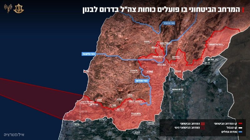
The map that is not a ceasefire
In southern Lebanon, by contrast, the messaging is loud, just not aligned with the action. According to the IDF map circulated at 10:10 UTC by the war-witness channel and confirmed by Open Source Intel at 10:15 UTC, Israeli forces are operating up to approximately ten kilometres north of the Blue Line — a depth that places well-known Lebanese towns and villages inside the declared zone. The map is, in the IDF's own language, a security zone. The word is the giveaway. A ceasefire line is bilateral, drawn, and respected by both sides. A security zone is unilateral, drawn by one side, and respected because the other side cannot dislodge it.
The context matters. A November 2024 arrangement formally ended the open phase of the Hezbollah-Israel front, but the terms have frayed in increments: airstrikes reported deep in the Beqaa Valley, intermittent rocket fire from south-of-the-Litani cells, the slow accumulation of Israeli forward positions under the rhetoric of "limited operations." The ten-kilometre figure is the first time the IDF has put a number on the depth in a publicly-issued graphic. It is a confession disguised as a clarification. The official line — that Israel is not occupying, is not re-occupying, will withdraw when the threat is gone — becomes harder to sustain when the army itself publishes a polygon ten kilometres deep.
The structural pattern
What links the two pieces of imagery is the gap between official vocabulary and on-the-ground geometry. In Moscow, the geometry is atmospheric: something is falling on the city that the authorities will not name. In southern Lebanon, the geometry is cartographic: a state has published a line, and the line is far from where the international community believes the border to be. Both are cases of sovereign actors managing perception because they cannot yet manage facts.
This is the texture of the post-2022 security order. The major regional and extra-regional powers talk in the language of restraint, de-escalation, and red lines. Their forces operate in the language of depth, buffer, and reach. The mismatch is not new — it is the central diagnostic of every conflict since the Iraq-war gap between WMD rhetoric and warehouse reality. What is new is the openness with which the gap is now displayed. The IDF publishes its map. The Russian state allows an unidentified film to settle on its capital's cars. Open-source accounts, working from public video, do the documentation that official press conferences will not.
What the next weeks will tell
The stakes are concrete on both fronts. If the Moscow residue is industrial, a clean technical explanation will emerge within days and the story will evaporate. If it is military, expect a renewed Ukrainian claim of reach, a Russian counter-claim of provocation, and another iteration of the missile-versus-refinery duel that has defined the war's third year. If it is something the authorities cannot yet classify, the silence will lengthen until a narrative is constructed, and the constructed narrative will be the news.
In southern Lebanon, the IDF map is a commitment device. Having published the polygon, the IDF has made a withdrawal into a choice that must be defended politically, not just operationally. The Lebanese state, the UN Interim Force in Lebanon, and the governments underwriting the November 2024 arrangement will be obliged to respond — either by treating the map as a negotiating fact, or by treating it as a violation. Each response forecloses the others. There is no neutral read of a published security zone.
Desk note: Monexus treats the two incidents as data points, not conclusions. The Moscow footage is unverified in origin; the IDF map is verified in authorship. Both are useful precisely because they are public, dated, and resistant to official spin.
Wire provenance
This editorial synthesis draws on the following public wire/social posts:
- https://twitter.com/Osint613/status/2067558417313489114/video/1
- https://t.me/osintlive
- https://t.me/wfwitness