Twin earthquakes off Venezuela's coast leave La Guaira reeling as rescue teams dig through the rubble
Two tremors struck Venezuela's central coast on 28 June 2026, with the worst damage concentrated in the port state of La Guaira, where drone footage shows collapsed structures and rescue crews still pulling survivors from the debris.
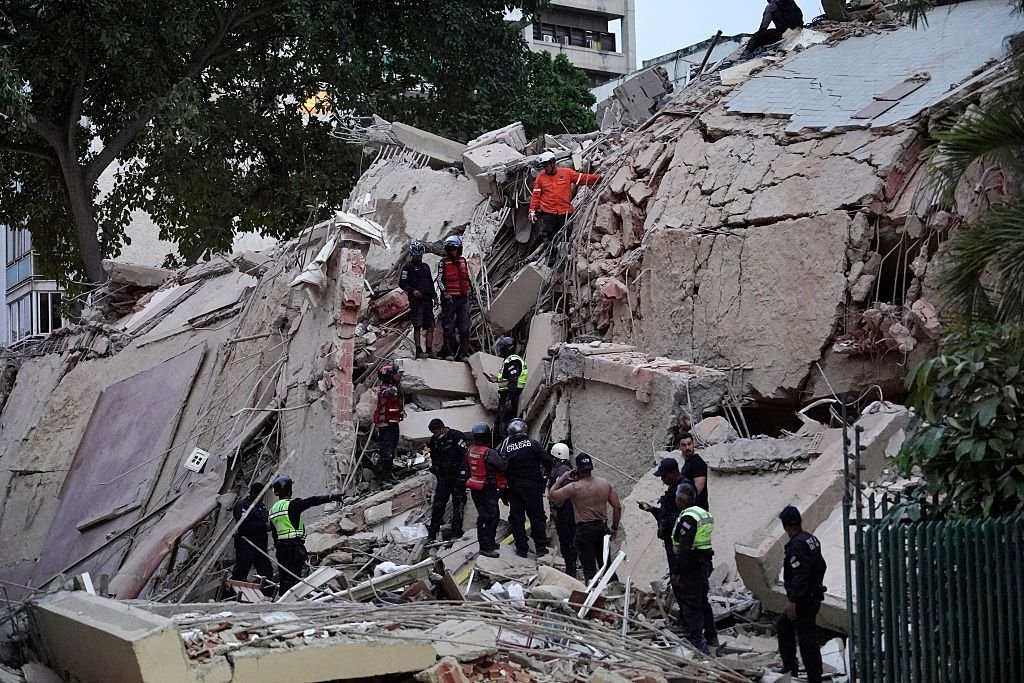
Drone footage released at 18:06 UTC on 28 June 2026 shows streets buckled, rooftops caved in, and rescue crews working through rubble in La Guaira, the small coastal state that sits just north of Caracas and houses Venezuela's principal port. The clips, circulated by Iran's Tasnim news agency through its English-language Telegram channel, depict the kind of damage that follows a shallow, near-shore earthquake sequence: facades sheared off low-rise buildings, vehicles crushed under masonry, and what appears to be a partially collapsed coastal highway.
The twin tremors hit on the afternoon of 28 June 2026, according to Al Jazeera English's breaking-news feed, which posted a separate drone video at 16:38 UTC showing ongoing rescue efforts in the same stretch of coast. The geography is significant: La Guaira is not Caracas, but it is functionally Caracas's outlet to the Caribbean, and any prolonged damage to its road, port, or power infrastructure ripples inward to the capital within hours.
What the footage actually shows
The Al Jazeera clip, captioned simply as "drone footage from Venezuela's La Guaira," shows the same pattern visible in the Tasnim material: rescue workers on foot picking through what remains of multi-unit residential blocks, with bystanders clustered at a safe distance. Both videos are short, shot from above, and consistent with the early hours of a search-and-rescue operation rather than the longer arc of recovery. That matters because the visual record so far captures only a fragment of the affected footprint — drone overflights tend to follow main access roads, leaving the narrower hillside barrios of La Guaira state largely undocumented.
The Tasnim channel, citing its correspondent @JahanTasnim, repeated the line that the damage was caused by "2 earthquakes" — a framing consistent with the seismic pattern in this part of the Caribbean, where the boundary between the South American and Caribbean plates routinely produces doublet events rather than a single main shock followed by aftershocks. The two clips, posted 32 minutes apart, are not contradictory footage of the same tremor; they read as successive overflights of the same disaster zone.
The structural setting
Venezuela sits on the northern edge of the South American plate, where it grinds against the Caribbean plate along a complex system of strike-slip and thrust faults. The country's recorded seismicity is heaviest along this northern coast — the same corridor that runs through Carabobo, Aragua, the Distrito Capital, and La Guaira. A 2024 sequence of moderate tremors in the region produced localised damage without triggering a national emergency; the 28 June 2026 events, judging by the drone footage, sit in a different category.
La Guaira state is unusually exposed for two reasons that are geographic rather than political. Its terrain is narrow, mountainous, and tightly packed: population centres cling to a strip between the Ávila massif and the sea. Its soils are loose in places, a legacy of the 1999 Vargas tragedy that killed thousands in flash floods and landslides along this same coast. And its infrastructure — much of it dating to the mid-twentieth century — was built before modern seismic codes were enforced.
The reporting gap
What the available footage does not yet establish is the human toll. Neither the Tasnim dispatch nor the Al Jazeera breaking-news post at 16:38 UTC carried casualty figures, and the wire services that would normally aggregate those numbers — Reuters, AFP, AP — had not posted a confirmed count at the time the drone clips circulated. The absence is itself a data point: in a country where state media is politicised and independent press access is constrained, early disaster reporting tends to lag the visual record by several hours. The pattern has been visible in previous Venezuelan disasters, including the 2017 rains and the 2020 fuel-storage explosion at the Supertanker terminal outside Caracas, where international wires converged on verified figures only after on-the-ground journalists and local civil-defence accounts crossed into the open record.
This publication's read is that the next 12 to 24 hours will determine whether the 28 June sequence is remembered as a contained local event or as the trigger for a regional humanitarian response. The first indicator will be the casualty figure from Venezuela's civil-defence agency (Protección Civil), which historically has been the authoritative domestic source but whose early statements are often revised. The second will be whether the country's principal airports — Maiquetía, serving Caracas through La Guaira state, and the international Simón Bolívar at the port — remain operational. The third will be the first independent reporting from Caracas-based outlets, which under current access conditions tends to surface through diaspora networks and Latin American wires rather than through domestic simulcast.
Stakes
The immediate stakes are physical and local: rescue crews working against a clock that starts when a person is buried under rubble and ends roughly 72 hours later. The medium-term stakes are economic. La Guaira's port complex handles the bulk of Venezuela's containerised imports and a significant share of its fuel distribution; any sustained interruption pushes pressure onto the overland routes through Colombia, which are already strained. The longer-arc stakes are political. A natural disaster of this scale, hitting a coastal corridor that includes both working-class barrios and the symbolic infrastructure of the capital, will test the Maduro administration's ability to mount a visible response at a moment when its legitimacy is already contested internationally and its domestic audience is fragmented.
What remains genuinely uncertain, even after the drone footage has circulated, is the depth of the damage in the hillside settlements that the overflights do not reach. The visible record captures the front of the disaster. The harder accounting — the count of the displaced, the map of the uninhabitable buildings, the state of the road and rail links into Caracas — will require ground reporting that, as of the 18:08 UTC Tasnim dispatch, had not yet entered the open record.
Desk note: Monexus is leading with the drone footage and the seismic-setting context rather than any single wire casualty figure, because at the time of writing no verified count has crossed the wire. Where state-aligned and Iranian state-media sources are available, this publication cites them by name — as Tasnim is cited here — without inflating their evidentiary weight, and reads them alongside independent Western reporting where both exist.
Wire provenance
This editorial synthesis draws on the following public wire/social posts:
- https://t.me/tasnimnews_en
- https://t.me/JahanTasnim
- https://t.me/ajabreaking/
- https://en.wikipedia.org/wiki/La_Guaira
- https://en.wikipedia.org/wiki/1999_Venezuela_floods
- https://en.wikipedia.org/wiki/South_American–Caribbean_plate_boundary