Masafer Yatta raid exposes the legal fiction behind 'state land'
A settler raid in Umm al-Khair, abetted by occupation forces, lands on a village the world’s highest court has already told Israel to leave alone. The pattern is the point.
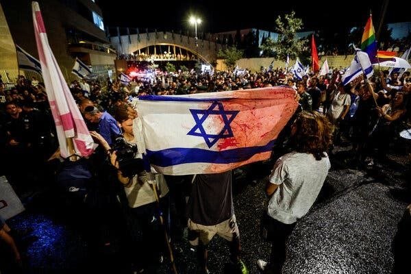
On 3 July 2026, a group of Israeli settlers, accompanied by Israeli occupation forces, entered the Palestinian village of Umm al-Khair in the Masafer Yatta area of the occupied West Bank and attempted to raise an Israeli flag inside it. The footage, circulated by regional outlets including The Cradle Media at 09:46 UTC on 4 July, sits in a long line of similar incidents and a longer line of legal findings that the village, and the broader firing-zone designation it sits inside, was never supposed to host this kind of operation in the first place.
The day's events are not a fresh outrage. They are a routine one — and routine is the story.
A village the court already named
Umm al-Khair is one of around a dozen Palestinian hamlets strung across the rocky hills south of Hebron that make up what Israel designates "Firing Zone 918." Israel's domestic legal architecture treats the land as state property because the Palestinian residents were reclassified, decades ago, as present "without authorisation" on what the state declares a closed military area. Under that fiction, demolition orders, livestock restrictions, school blockades and settler-escorted visits follow as administrative consequences rather than political choices.
That classification has already been adjudicated. In July 2024 the International Court of Justice, in its advisory opinion on the illegality of Israel's occupation, found the broader settlement enterprise unlawful and called on Israel to dismantle it. The European Union's foreign-policy arm has since incorporated that finding into formal language on settlement products. The village councils of Masafer Yatta have, separately, taken their case to domestic Israeli courts for years, repeatedly losing at the High Court of Justice on a question of evidence — whether the area is in fact used for live-fire training — rather than on the underlying legal right of residents to remain.
The 3 July raid therefore landed on a community whose presence the international legal consensus has already vindicated, and which the occupying power continues to administratively erase.
Why the settlers were not acting alone
The framing that recurs in sympathetic coverage — "renegade settlers," "extremists," "a fringe" — obscures the structural fact that the raid took place under the visible accompaniment of Israeli occupation forces. When soldiers accompany a flag-raising delegation into a village whose residents have filed dozens of petitions, the relevant variable is not the ideology of the marchers. It is the operational decision of the unit that opened the gate.
This is not a marginal observation. The pattern repeats across the South Hebron Hills: flocks herded off grazing land; wells restricted to specific hours; agricultural structures demolished in overnight operations; periodic incursions during which flags are raised and photographs taken. The same flag, raised under the same protection, on the same legal-classified land, in communities the ICJ has named.
A counter-reading holds that these are isolated provocations that don't represent state policy and that the legal architecture, however one reads it, leaves room for ordinary Palestinian life. It is a reading the village elders reject in writing and on camera, and that the ICC's pending jurisdiction in Palestine does not appear to share.
State land as administrative technology
The category "state land" is doing heavy lifting here, and it merits more attention than it usually receives. Across the occupied West Bank, some 60 percent of territory recorded as "state land" was so designated through a sequence of procedures — Ottoman and British-era land registers, the 1967 Military Order Concerning Land, the civil administration's "survey" apparatus — that Israeli human-rights groups B'Tselem and Kerem Navot have spent years documenting. The cumulative effect is a system in which Palestinian land becomes Israeli land through paperwork that operates below the threshold of international headlines.
That is the structural frame. A flag-raised in Umm al-Khair is a photo opportunity. The slow administrative conversion that lets the flag be raised is the policy. Whatever happens to the individuals photographed on Thursday will not affect whether the next survey block in the South Hebron Hills is reclassified next month.
Stakes beyond the morning news
Three audiences are watching. The ICC prosecutor's office, which has been examining settlement-related activity as part of a broader case, will read this incident against a documented pattern. The European Union, whose member states have begun formalising the ICJ opinion in customs and labelling decisions, will continue calibrating its distinction between Israel and the territories. The Palestinian Authority's internationally-backed reform agenda, which depends in part on holding ground in Area C, will register another data point on whether diplomatic process can outflank administrative erasure.
The villagers themselves face the simpler calculus: how much more footage they are willing to upload before someone with authority decides to act on it.
How this desk framed it: the wire services will treat the 3 July raid as one incident among several. The more useful lens is administrative — what "state land" allows, who authorises the gate to open, and what the courts have already said about the underlying claim. The pattern is the policy; the photograph is just the paperwork made visible.
Wire provenance
This editorial synthesis draws on the following public wire/social posts:
- https://t.me/thecradlemedia
- https://t.me/TheCradleMedia