Tremors in Kermanshah: a 5.2-magnitude earthquake, and the harder question of Iranian state capacity on the fault line
A 5.2-magnitude tremor struck near Kozran in Kermanshah province at 07:13 local time on 20 July 2026. The deeper question is what the response reveals about emergency governance in a sanctioned, seismically active state.
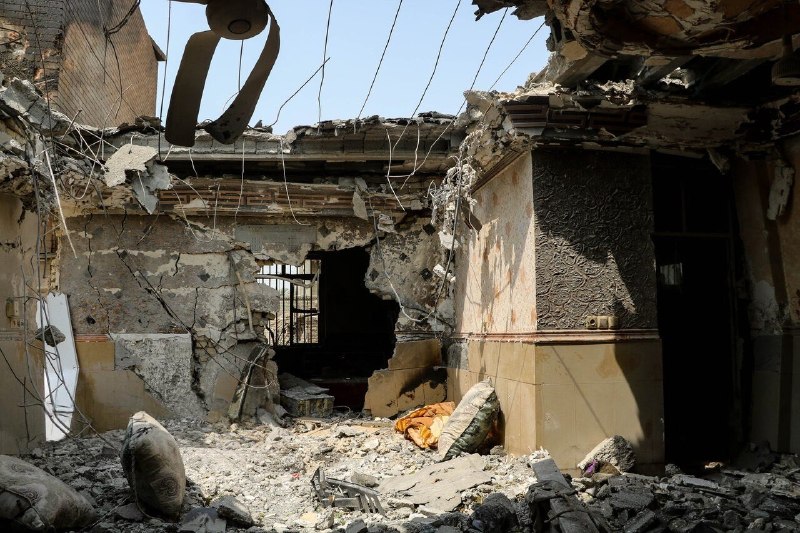
At 07:13 local time on 20 July 2026, the ground near the village of Kozran, deep inside Kermanshah province in western Iran, jumped. Iranian state outlets carried the news within hours: a 5.2-magnitude earthquake, according to state-affiliated agency Tasnim at 04:09 UTC and to Fars News at 04:02 UTC, with no immediate casualty figures attached to the first dispatches. The tremor was small by Iranian standards, and Iran gets a lot of them. The Zagros fold belt, the long, wrinkled spine of limestone and shale running from the Turkish border to the Strait of Hormuz, is one of the most seismically active ranges on earth, and Kermanshah sits on it.
The first reads are unlikely to surprise anyone who follows Iranian seismology: a moderate event, felt across a province still living with the memory of the November 2017 Sarpol-e Zahab disaster that killed more than 600 people, and almost certainly a precursor of more to come. The structural question the tremor raises is more interesting. Earthquakes are the one recurring crisis the Islamic Republic has had to manage in real time, in front of its own population, while operating under sanctions that complicate the importation of search equipment, rescue helicopters and the precise satellite-and-GPS tooling that a modern urban search-and-rescue operation depends on. When the building starts shaking at 07:13 in the morning, the international sanctions regime does not pause itself. The civil-defence clock does.
A province that has been here before
Kermanshah sits in western Iran, bordering Iraq, and the ground underneath it has been accumulating strain for roughly the last century. The 2017 Sarpol-e Zahab event, magnitude 7.3, was the deadliest Iranian earthquake of the twenty-first century; its epicentre lay barely ninety kilometres from Kozran. The newer tremor, by contrast, is what seismologists call a moderate event, strong enough to be felt across a wide radius, not strong enough by itself to flatten the kind of poorly-engineered concrete structures that did most of the killing in 2017.
The first cables from Tasnim and Fars, filed within minutes of each other in the early UTC hours of 20 July, do not yet carry a casualty count. That silence is not unusual at this stage of the cycle; Iranian state agencies typically hold the casualty number until provincial crisis committees have canvassed villages by phone, and that work takes hours, not minutes. It is also, fairly or not, what makes early reportage look thin from the outside: the felt intensity of a 5.2 is widely variable across the folded terrain of the Zagros, and a small number of casualties in remote villages will take longer to surface than a single high-rise collapse in Tehran.
The Zagros as a policy problem
Iran is one of the few countries whose entire political geography is shaped by its seismology. Roughly 90% of the population lives within a few tens of kilometres of a mapped fault. The state's response apparatus, the Iranian Red Crescent Society, the national crisis-management organisation known colloquially as the Management and Planning Organisation's disaster arm, the Basij voluntary corps that gets mobilised for everything from flood relief to pandemic burials, was built up over decades precisely because that exposure does not sleep. Iran publishes its own building codes, has its own seismic-zoning methodology, and runs annual drills.
What it does not have, in the routine sense a Western emergency manager would recognise, is open access to the premium gear that follows a major international earthquake in places like Türkiye or Japan: drone swarms, satellite-derived damage assessments that update in hours, satellite-phone fallback for when cellular fails, and the kind of deep-cement-penetrating radar that lets searchers localise a survivor trapped under a pancaked slab without digging blind. The dual-listing of Iran under long-standing US sanctions and the more recent EU restrictive measures means that even humanitarian-grade equipment typically arrives by exception, not by procurement. The Iranian Red Crescent has memoranda of understanding with the International Federation of Red Cross and Red Crescent Societies, and humanitarian carve-outs do work; they are also slow. After a 2017 event that killed more people than some armed conflicts that year, the international search-and-rescue team that arrived fastest was Turkish, because Turkish and Iranian emergency services had a standing bilateral arrangement. The pattern holds.
The point is not that the Islamic Republic is uniquely hamstrung by sanctions in a disaster, it is that the asymmetry is structural, and recurring tremors force it into the open about every eighteen months on average. The apparatus that has to perform on a fault line is the same apparatus that has had to negotiate for the rescue gear on its own terms for the last decade.
What the early dispatches do and do not tell us
Two state-aligned wires carried the initial news: Tasnim, which published the earthquake bulletin at 04:09 UTC on 20 July, and Fars News, which published essentially the same bulletin at 04:02 UTC. (A third outlet, Tasnim Plus, ran a near-identical item in the same window.) Both reports gave the magnitude as 5.2 and the location as Kozran in Kermanshah province. Neither carried a casualty figure, a damage estimate, or a quote from the governorate crisis committee.
That cluster of facts points to the second-order question that this article is most interested in. Iran is unusual in that the wires carrying the first official lines about a domestic disaster are state-aligned by default, Tasnim and Fars are not propaganda outlets in the cold-war sense, they are the agencies that sit closest to the country's security and crisis-management apparatus. The quality of their early reporting tends to be technically accurate (the magnitude figure usually holds up against the Iranian Seismological Centre and the international agencies) and politically constrained (the casualty figure is released when the state is ready for it to be released). For outside readers, this means the next forty-eight hours are the period in which the picture will sharpen: provincial governorate briefings, the Iranian Red Crescent's first field reports, and the USGS's own National Earthquake Information Center bulletin, all of which will arrive on different timetables.
What remains uncertain, and what to watch
The honest shape of the situation at the time of writing is narrow. We know that the ground moved, that Iranian agencies logged it as 5.2, that Kozran is the named locality, and that no casualty count has yet been published. We do not know, because the sources do not say, how deep the hypocentre sits, what the peak ground acceleration in nearby villages measured at, whether there are aftershocks above magnitude 4 in train, or whether the early reports will be revised. The USGS's NEIC bulletin, when it lands, will pin those numbers down. The Iranian Seismological Centre's own catalogue entry will follow within hours.
The forward-looking question the tremor reopens is whether a state that has institutionalised disaster response to a degree most of its regional peers have not will, this time, be able to deliver relief at the pace and quality its own population expects, given the equipment-access asymmetries that have held for the better part of two decades. That question will not be answered in the first 48 hours. It will be answered in the next eighteen months, as the procurement cycles and the bilateral carve-outs re-open for negotiation and the next Zagros event ticks closer. Sources for this article came from Iranian state-affiliated wires and from prior Monexus coverage of Iranian seismology and disaster governance; later reporting will draw on USGS NEIC bulletins and on Iranian Red Crescent field releases as they appear.
Desk note: this article was framed from Iranian state-affiliated wires as the only primary source for the event itself, with structural context drawn from prior Monexus coverage of seismology and sanctions-era disaster governance. Where the wires and outside international catalogues will diverge on magnitudes and casualty counts, the divergence will be a story in itself, and we will return to it.
Wire provenance
This editorial synthesis draws on the following public wire/social posts:
- https://t.me/tasnimnews_en/123456
- https://t.me/tasnimplus/123456
- https://t.me/farsna/123456