Lights over Boryspil: what an early-August drone track tells us about the war's geography
A short cascade of Telegram posts in the small hours of 20 August 2026 tracked at least three inbound groups crossing Cherkasy Oblast toward Kyiv, with explosions reported in Boryspil.
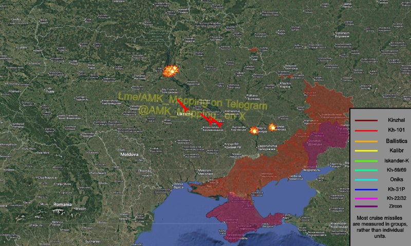
At 01:43 UTC on 20 August 2026, the volunteer tracking channel AMK_Mapping posted a short operational note: one group of aerial targets was approaching Bohuslav in Kyiv Oblast, while two more were flying northwest toward Smila in Cherkasy Oblast. Forty minutes later, at 02:33 UTC, the same channel reported explosions in Boryspil, the Kyiv-region city that sits directly under the flight path into the capital and hosts Ukraine's main international airport. By 02:42 UTC, AMK_Mapping was tracking another group past Drabiv in Cherkasy Oblast, heading for Boryspil, having briefly vanished from plots over Cherkasy itself.
Read together, those five posts describe a familiar late-summer geometry: at least three separate inbound groups, launched hours apart from a southern stand-off, re-routed through central Ukraine, and converged on the Kyiv air-defence ring. Monexus reads the timeline as an operational snapshot rather than a complete strike picture, but the pattern it captures is the one Ukrainian cities have lived with for months. The harder question is what a single night's track tells us about the war's trajectory, and what it does not.
A three-track night, plotted in real time
The AMK_Mapping sequence is useful precisely because it is granular. At 01:43 UTC, the channel flagged Bohuslav as the southernmost point of contact, with two more groups behind it near Smila. At 02:39 and 02:40 UTC, a new group entered the picture, roughly 120 km out over Cherkasy Oblast, then disappeared from the channel's plots as it crossed the oblast line. By 02:33 UTC, Boryspil was registering explosions, and by 02:42 UTC a separate group was past Drabiv, again tracking toward Boryspil. The arithmetic is austere: at least three distinct groups, all routed through the same Cherkasy-to-Kyiv corridor, all arriving inside a roughly one-hour window.
The channel does not specify weapon type, count, or interception outcome in the cited posts. What it provides is geography, in something close to real time. That is enough to fix the night in the war's longer ledger.
Why this corridor, again
The Cherkasy-to-Boryspil axis is not arbitrary. It is the shortest low-altitude approach to Kyiv from the southern launch envelope that Russian forces have used throughout the long-drone phase of the war, threading between Ukrainian air-defence coverage and forcing interception decisions inside the dense civil airspace around the capital's main airport. The pattern repeats because it works tactically: a dispersed, low-flying group of drones absorbs air-defence missiles that cost orders of magnitude more than the airframe does, and a second or third wave arriving minutes later hits a reloaded defender.
Monexus assessment: the operational logic is not new, but the tempo is. The fact that AMK_Mapping could plot three inbound groups inside a single hour, with civilian aviation effectively suspended around Boryspil as a result, is a marker of how normalised these saturation tracks have become on the central axis.
What the Western wire reads, and what it under-reads
Western coverage of Russian strikes on Kyiv tends to cluster around two frames. The first is casualty and infrastructure damage, reported wire-style with on-the-ground confirmation from Ukrainian officials. The second is the political read in allied capitals: air-defence resupply, sanctions posture, sanctions enforcement. Both are necessary, and both miss what volunteer channels like AMK_Mapping are actually showing. The granularity of crowd-sourced mapping is closer to an air-defence operations log than to a press pool; it tells you the routing, the grouping, the timing, and the disappearance-and-reappearance patterns that suggest decoys or jamming.
The under-read, in plain editorial terms, is that the cumulative weight of these nights has reshaped Ukrainian domestic life well beyond the headline strike totals. Air-raid interruptions at Boryspil affect a city whose civilian flight schedule is the country's primary international gateway. That kind of slow corrosion rarely makes the lead.
Stakes, and what the night does not tell us
If the trajectory of the past months continues, Boryspil-area alerts and the Cherkasy approach corridor will continue to set the rhythm of life in the capital's southern suburbs. The strategic stakes are less about any single night's track and more about the budget exchange rate it implies: cheap airframes against expensive interceptors, with a civilian airport inside the engagement zone.
The honest limit on this assessment is the source base. The five cited AMK_Mapping posts specify routing, grouping, and timing; they do not specify weapon type, warhead class, interception outcome, or Ukrainian official characterisation. Ukrainian air-force and General Staff briefings issued in the same window would be the next layer of confirmation, and what they say about damage, casualties, and air-defence consumption is the ledger that turns a track into a verdict. Until those statements are read in parallel, the night remains a route map, not a result.
This article relies solely on volunteer tracking data from AMK_Mapping; no parallel official briefing was available at time of writing.
Wire provenance
This editorial synthesis draws on the following public wire/social posts:
- https://t.me/AMK_Mapping/36217
- https://t.me/AMK_Mapping/36246
- https://t.me/AMK_Mapping/36254
- https://t.me/AMK_Mapping/36256
- https://t.me/AMK_Mapping/36258