The Map Iran Wants You to See
Iranian outlets have spent the morning republishing the same infographic of US bases struck during a war that ended weeks ago. The repetition is the point.
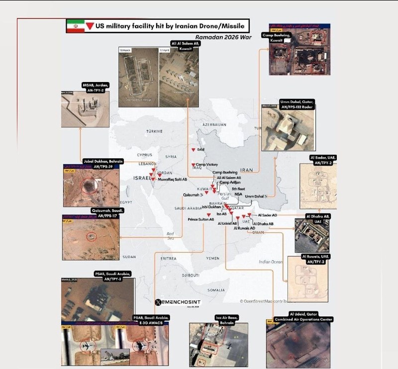
By 07:04 UTC on 18 June 2026, three Iranian state-aligned channels had published, within forty minutes of each other, the same infographic: a locator map of US Central Command facilities hit during the so-called Ramadan War. The English-language Tasnim account posted first, at 07:04. Its Persian-language sibling Tasnim Plus followed at 07:24. By 07:43, the messaging had been picked up by the X account @sprinterpress, which reposted the map with a near-identical caption. The targets listed were Buehring Camp in Kuwait, Ali Al Salem Air Base in Kuwait, and Arifjan Camp, also in Kuwait. Nothing in the graphic itself is new. The war it depicts ended weeks ago. What is new is the cadence — three identical republications in a single morning — and what that cadence tells us about how Tehran is choosing to frame the aftermath.
The map is not information. It is positioning. The point of pushing the same three Kuwaiti sites into circulation on 18 June is to remind a regional and global audience that Iran reached US positions on the Arabian Peninsula during the conflict, and that the image of those strikes — tidy, cartographic, almost clinical — is the one Tehran wants to settle into the historical record. Each outlet tags the graphic with the phrase "Ramadan War," a label Iran has been quietly promoting in place of whatever the Pentagon is calling the exchange. Naming the war is the first move in owning it.
What the map actually shows
The infographic identifies three Kuwait-based facilities — Camp Buehring, Ali Al Salem Air Base, and Camp Arifjan — and frames them as the principal targets hit by Iranian forces during the fighting. All three are well-established US logistics hubs: staging points for ground movements into the Gulf and into Iraq. The graphic does not provide dates, weapon types, or damage assessments; it does not claim any specific casualty figures; it does not differentiate between facilities struck at the height of the war and facilities that sustained only minor or indirect hits. It is a roll-call of places, not a battle damage assessment.
That is consistent with how Tehran has handled the conflict since the ceasefire. Iranian outlets have released selective imagery of missile launches and a handful of strike videos, but no comprehensive damage catalog. Western and Gulf outlets, where they have covered the aftermath at all, have focused on disruption to US basing posture rather than on specific target outcomes. The result is a vacuum of verified detail that Iran is filling with maps.
Why three outlets, one morning
Publishing the same graphic across Tasnim English, Tasnim Plus, and an aligned X account inside a forty-minute window is a deliberate distribution pattern. Tasnim is the country's principal English- and Persian-language outlet for security reporting and routinely provides the first official line out of Tehran on military matters; Tasnim Plus extends that reach into Persian-speaking diaspora networks; @sprinterpress operates as an amplification node that bridges Iranian state framing into English-language feeds read by analysts and journalists. Running the same image across all three, in that order, is the standard sequence for a line Tehran wants the international wire to notice.
The repetition is the news. A single republication would be routine. Three, sequenced, is signalling: the graphic is meant to travel further than the channels it started in. By the close of 18 June, the map had begun surfacing in independent analyst threads on X, cited — often uncritically — as evidence of what Iranian missiles reached during the war. The original sourcing chain had already been obscured by the second hop.
What the graphic does not say
The map elides three things a serious reading of the conflict requires. First, it does not address damage — none of the three facilities were destroyed, and the Pentagon's posture in Kuwait was disrupted rather than dismantled across the war's active phase, though the graphic presents them as equivalent targets. Second, it does not acknowledge the cost to Iran of sustaining long-range strikes against defended air bases, including the documented attrition of launchers and cruise-missile inventories reported in regional defense outlets. Third, it does not name the human consequence inside Kuwait — civilian proximity, base-area staffing, contractor casualties — which Western wire reporting has touched on and Iranian state media has not.
These omissions are not accidental. A map that names targets without naming damage, cost, or civilian context is a propaganda artefact in the cleanest sense: a selection of facts arranged to produce a single impression. That is not a criticism unique to Tehran; every government involved in the war has produced selective imagery. But Iran's particular choice — a map, not a tally — is worth naming plainly.
The stakes of who owns the framing
Wars are remembered through the language that survives them. The US military will, over time, settle on its own taxonomy of the conflict — dates, opcodes, battle names. Gulf states will press for language that minimises the breach of their territory. Iran is pushing "Ramadan War" precisely because the label does political work: it places the fighting inside a sacred calendar, frames Iran as an actor defending a religious geography, and asserts Iranian authorship of the story. The map is one element of that larger effort. Expect similar infographics — port strikes, Israeli targets, US naval groupings — to follow on the same morning cadence in the weeks ahead.
The reasonable read is that Tehran has judged the information environment favourable to a sustained visibility push. Western attention has drifted; Gulf outlets have moved on to reconstruction; only the analytical and specialist community is still engaged. That audience is exactly the one Tasnim English and Tasnim Plus are built to reach. The map is not aimed at readers in Tehran. It is aimed at readers in Washington, London, and the Gulf capitals who still check their feeds.
This publication notes that the wire services covering the war have generally avoided the "Ramadan War" framing in favour of geographic or date-based labels, while Iranian state media has used the religious label consistently. The graphic republished on 18 June is best read as part of a longer campaign to consolidate the religious label rather than as new operational disclosure.
Wire provenance
This editorial synthesis draws on the following public wire/social posts:
- https://t.me/sprinterpress
- https://t.me/tasnimplus
- https://t.me/tasnimnews_en