Reports of renewed US strikes across southern Iran sharpen the corridor question
At 16:21 UTC on 1 September 2026, multiple monitoring channels reported renewed US attacks around Bandar Abbas, Qeshm and Konarak. The claims point to a widening confrontation along Iran's southern coast, but the available accounts do not independently establish the targets or the scale of damage.
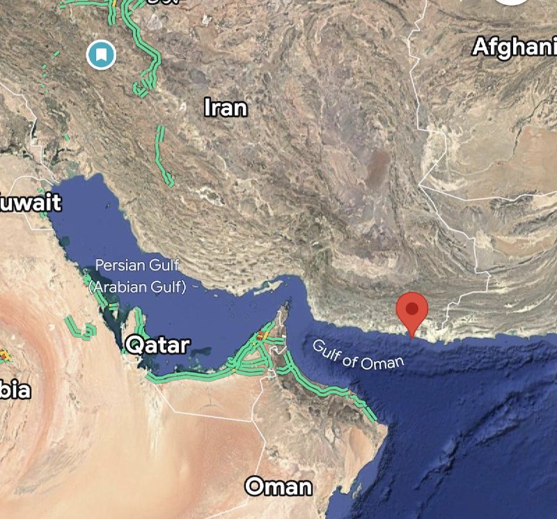
At 16:21 UTC on 1 September 2026, a monitoring channel reported renewed airstrikes on Bandar Abbas and two new US attacks on Qeshm Island in southern Iran. Separate posts at 16:12 and 16:13 UTC carried reports of explosions in Bandar Abbas and on Qeshm Island, while later items added Chabahar and Konarak to the list of locations. One channel said the cause of the earlier explosions was unknown. The sequence is important because it places the reported action along Iran's southern coast, close to the maritime approaches associated with the Strait of Hormuz.
The immediate claim is therefore not merely that explosions were heard. It is that a pattern of reported US attacks may be extending across several points in the same coastal system. The available source items do not independently identify the targets, weapons, damage, casualties, or the basis for attributing every reported blast to the United States. What they establish is a rapidly circulating account of renewed activity, with several locations named and the timing compressed into minutes.
That distinction matters. In a conflict where the geography itself carries strategic weight, early reports can shape expectations before official or independent confirmation catches up. The question is no longer only whether an attack occurred. It is whether Washington is applying pressure across a dispersed set of coastal positions, and what Iran, regional governments and shipping interests will do if that interpretation takes hold.
A coastal geography under pressure
The locations named in the posts form a coherent geographic cluster. Bandar Abbas is a major southern Iranian port city. Qeshm Island lies in the Strait of Hormuz, the narrow waterway linking the Persian Gulf with the Gulf of Oman. Chabahar and Konarak sit farther east along Iran's coastline. Their inclusion does not prove that every location was struck, but it gives the reporting a broader spatial shape than a single unexplained blast.
The timing also points to an evolving sequence rather than a single static claim. DD Geopolitics reported explosions in Bandar Abbas and on Qeshm Island, near the Strait of Hormuz, at 16:12 UTC, describing the cause as unknown in those items. A subsequent DD Geopolitics item at 16:13 UTC repeated the Bandar Abbas and Qeshm framing and again described the cause as unknown. Clash Report then listed Qeshm, Bandar Abbas, Chabahar and Konarak at 16:13 UTC, broadening the location set. At 16:18 UTC, rnintel reported US airstrikes on Konarak and renewed airstrikes on Bandar Abbas. Three minutes later, the same channel reported renewed airstrikes on Bandar Abbas and two new attacks on Qeshm Island.
Monexus analysis: the clustering is consistent with an attempt to widen the reported operational picture, but it does not by itself demonstrate a coordinated campaign across all four sites. The strongest defensible reading is that the publicly available reporting is moving from isolated explosions toward a claim of repeated attacks along a connected southern-Iranian coastal arc. The locations make the strategic relevance clear even before the target set is known.
The alternative explanation is simpler. Social and monitoring accounts may be compressing a smaller number of events, repeating earlier claims, or assigning causes before evidence is available. That possibility is especially important because several of the later posts explicitly repeat the same locations. Repetition can increase visibility without increasing the underlying evidentiary base.
Attribution is the central weakness
The most consequential wording comes from rnintel, which described the action as US airstrikes on Konarak and renewed airstrikes on Bandar Abbas, and later renewed airstrikes on Bandar Abbas and two new US attacks on Qeshm Island. That is a direct attribution, not a neutral account of an explosion. DD Geopolitics was more cautious, saying the cause of the explosions was unknown. Clash Report used the language of reports and explosions heard, while The Cradle Media reported explosions near the city of Bandar Abbas and Qeshm Island. The differences are not cosmetic. They identify the point at which a breaking alert becomes a claim about responsibility.
The supplied material contains no first-party US statement specifying the target list, mission objective, legal authority, or weapons used. It also contains no Iranian official account in the available items setting out damage, casualties, or a response. Those omissions do not establish that no such statements exist. They mean only that the source record supplied for this article does not provide them.
The appropriate standard is therefore narrow. The reports support saying that monitoring channels circulated claims of explosions and, in some cases, airstrikes at the named locations. They do not support presenting a complete strike count or a definitive assessment of military effect. The distinction should remain visible even as the story develops, because an unattributed account can still be strategically consequential if it changes the behaviour of governments, insurers, ports or shipping operators.
The corridor question
The southern coast is not an interchangeable backdrop. Bandar Abbas and Qeshm are closely associated with the maritime environment around the Strait of Hormuz, while Konarak and Chabahar extend the reported geography eastward. If the attacks were aimed at military, surveillance, transport or command infrastructure, the choice of locations could matter beyond Iran's borders. A strike on a populated urban area, a port, or an energy or transport facility would carry different consequences from an attack on an isolated military position.
The source items do not specify which of those categories applies. They also do not provide a confirmed operational duration, a verified number of aircraft, or a documented effect on shipping. It would therefore be an error to turn the reports into a claim that the Strait of Hormuz has been closed, that maritime traffic has been interrupted, or that a particular infrastructure facility has been disabled.
Still, the geographic concentration creates a corridor problem. States and companies do not need certainty about every target to price risk. Repeated reports of attacks near ports and islands can affect routing, insurance and the political calculations of governments that rely on the waterway. Monexus assessment: the strategic effect may begin with perceptions and precaution before it appears in confirmed physical damage. A corridor can become more dangerous when the parties involved believe that the other side is willing to operate across several points at once.
The counterpoint is that warnings can also harden positions without improving security. If each new post is treated as confirmed military action, escalation can outrun verification. Governments may announce defensive measures, shipping firms may reroute vessels, and media audiences may infer a planned operation that the evidence does not yet support. Restraint in language is not neutrality about the dangers. It is a way to preserve room for verification while the facts remain contested.
What would confirm the claim
A firmer picture would require several forms of evidence: an official US account identifying the operation, Iranian or local reporting that records the location and aftermath of each blast, satellite or other independent imagery consistent with the reported damage, and credible confirmation from regional or international institutions. The available posts provide a common location list, but they do not provide a chain of evidence connecting each named site to a specific aircraft, munition or military objective.
The first editorial checkpoint is attribution. rnintel's wording supplies the only explicit US claim in the supplied items, while DD Geopolitics says the cause of the earlier explosions was unknown. Those positions can coexist only if "US strike" is treated as a reported attribution awaiting corroboration, not as an independently verified event description. The second checkpoint is the target set. No supplied source item says what was hit. The third is scale. No supplied source item gives a reliable count of casualties, aircraft sorties, damaged facilities, or vessels affected.
Monexus analysis: the responsible conclusion at this stage is that southern Iran experienced a sequence of reported explosions and alleged US airstrikes on 1 September 2026, concentrated around Bandar Abbas, Qeshm, Chabahar and Konarak. The record is sufficient to describe the reports and their geographic spread. It is not sufficient to establish the operational scope or outcome.
The stakes are concrete. If the reports are confirmed and represent a broader pattern, Iran faces renewed pressure on its southern coast, while US forces and regional partners would confront the risk of Iranian retaliation and further escalation. If the reports are overstated, the danger is a feedback loop in which uncertain alerts harden political positions and influence public expectations before the underlying facts are settled. Either way, the next useful evidence will not be a louder repetition of the same claim. It will be a named official statement, independently visible damage, or reliable evidence that ties the reported blasts to a specific military action.
Desk note: Monexus framed the event as a reported sequence of explosions and alleged US strikes, preserving the geographic significance of Iran's southern coast without converting unverified social and monitoring claims into confirmed target or casualty accounts.
Wire provenance
This editorial synthesis draws on the following public wire/social posts:
- https://t.me/rnintel/65962
- https://t.me/osintlive/568778
- https://t.me/rnintel/65961
- https://t.me/thecradlemedia/67175
- https://t.me/ClashReport/94531
- https://t.me/ClashReport/94529
- https://t.me/DDGeopolitics/192321
- https://t.me/DDGeopolitics/192320