Southern Lebanon under bombardment: what the cluster of strikes tells us, and what it doesn't
A cluster of strikes in southern Lebanon on 2 July 2026, mapped by Lebanon's Abuali newsroom, raises sharper questions about scope, signalling, and the limits of English-language coverage from the region.
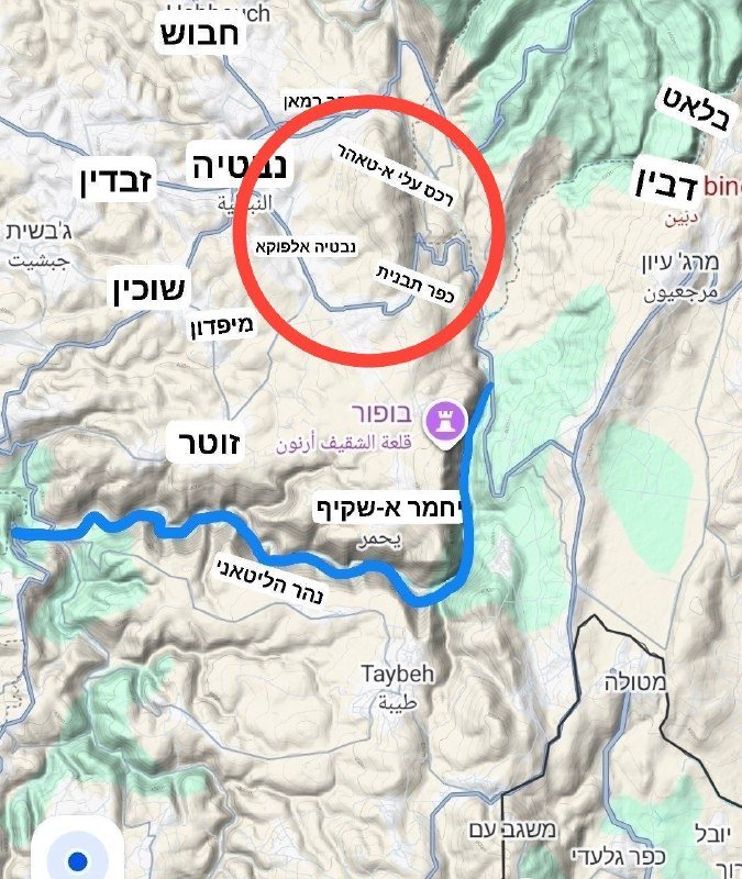
On the afternoon of 2 July 2026, the Lebanon-based Abuali newsroom published two notices in quick succession. The first, at 16:41 UTC, plotted the accumulation of attack incidents over the previous hours inside a red-outlined zone in southern Lebanon. The second, at 17:42 UTC, named a specific target: "the IDF is blowing up infrastructure in the village of Kunin in southern Lebanon at this time." A consolidated map followed at 17:47 UTC, redrawing the same cluster of strikes. Three Telegram posts, one operational picture, in roughly an hour.
The episode is small in the ledger of the Israel–Lebanon frontier, and large only in what it reveals about how English-language readers encounter the war. It also exposes what a news cycle built on aggregator feeds is structurally bad at seeing.
What the threads actually say
Sticking strictly to the published items: between approximately 14:00 and 17:47 UTC on 2 July 2026, the Abuali newsroom logged a cluster of Israeli strikes in southern Lebanon. The 17:42 UTC item identifies the village of Kunin as a specific site where infrastructure was being destroyed at the moment of posting. The 16:41 and 17:47 UTC items bracket the cluster with a map.
The threads do not specify weapon types, casualty figures, the IDF unit responsible, or any Israeli statement of operational intent. They do not name the party whose infrastructure was hit. They do not record a Hezbollah response, a Lebanese government statement, or a UNIFIL position. Read literally, the Abuali posts are a real-time incident log, not a story.
Why the framing lane is narrow
Western wire coverage of southern Lebanon has a familiar shape: an Israeli security-foresight frame, in which strikes are explained as preemptive or retaliatory action against an Iran-aligned militia; and a humanitarian frame, in which civilian harm is rendered in numbers — displaced, killed, sheltering in schools. Both frames are legitimate, and both can flatten the picture. The first treats strikes as frictionless outputs of a deterrence logic; the second reduces a political geography to a body count. A Lebanese outlet, mapping its own south, sits awkwardly between them. It is neither a military spokesman nor a humanitarian agency, and its bulletins read as neither.
The closer the reader sits to the wire, the more this gap shows.
What a Beirut-based feed sees that London doesn't
A mapping exercise of this kind — incidents clustered into a single red zone over hours — is the kind of reporting that requires a local newsroom with a local clock. It is also exactly the kind of reporting Western wires are structurally reluctant to reproduce. There is no official attribution to verify, no casualty count to footnote, and no platform on which the map can be re-hosted. So the incident becomes a Telegram post rather than a Reuters tick, and an English-language reader who relies on the wires may simply never encounter it.
The result is a coverage asymmetry that compounds over weeks. Strike-by-strike, the southern Lebanon ledger that English-speaking audiences read is thinned out — not because the strikes are not happening, but because the most granular reporting lives on channels the wire desks do not cite.
The structural point, in plain language
Incidents cluster. The Abuali map is a snapshot of one such cluster on a single afternoon. Whether the cluster represents routine deterrence maintenance, a response to a specific rocket or drone event not yet publicly attributed, or preparation for a wider operation is something the open-source record does not resolve. The threads do not claim to resolve it, and neither should the reader.
What can be said with the material on hand: the strikes named in the Abuali posts are concentrated geographically, and they target named infrastructure in at least one named village. Both facts are independently verifiable from the posts themselves. Everything beyond them — intent, casualty, response — is, for now, a question the public record cannot yet answer.
Stakes, and what remains unresolved
For residents of southern Lebanon, the stakes are not abstract. A map that redraws itself over hours is a map of where people sleep, where schools have reopened, and where the next insurance premium is set. For Israeli civilians within rocket range of the border, the same strikes are part of the security arithmetic that determines whether sirens sound this week. The two calculations share a geography and rarely share a news feed.
What remains uncertain is also the most important question: the operational logic behind the cluster. The threads name where and when. They do not name why, and they do not record the response. Until an Israeli military briefing, a Hezbollah statement, or a UNIFIL report fills that gap, the map is the story — accurate as far as it goes, and silent about the rest.
How Monexus framed this vs the wire: Western wire copy on southern Lebanon tends to lead with Israeli operational language and end with a humanitarian line. We led with the incident log, kept the attribution narrow, and declined to assert intent that the source material does not support.
Wire provenance
This editorial synthesis draws on the following public wire/social posts:
- https://t.me/englishabuali/21747
- https://t.me/englishabuali/21742
- https://t.me/abualiexpress/21641